Marsh Lake local area planning
The governments of Yukon, Kwanlin Dün First Nation and Carcross/Tagish First Nation are developing a local area plan for Marsh Lake.
What is local area planning?
Local area plans guide the development and use of land in unincorporated Yukon communities. The plans designate areas for specific land uses. Learn more about local area planning.
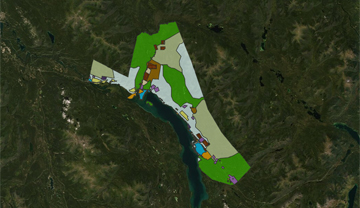
The planning area
The Marsh Lake plan area is approximately 376 square kilometres. The area extends from the north shoreline of Marsh Lake, east to Judas Creek, north to Michie Creek and west to the northern tip of the Lewes Marsh Habitat Protection Area.
What’s happening now?
The governments of Yukon, Kwanlin Dün First Nation and Carcross/Tagish First Nation recently signed an agreement to work together to update and complete the 2016 draft. The 3 parties are working together to complete the local area plan.
Contact the planners
Tomoko Hagio
Government of Yukon
Land and resource planner
Phone: 867-334-5425
Email: tomoko.hagio@yukon.ca
Doris Dreyer
Carcross/Tagish First Nation
Land Planner, MCIP, RPP
Phone: 236-795-4280
Email: den3ena@gmail.com
Roy Neilson
Kwanlin Dün First Nation
Land and resource planner
Phone: 867-332-1717
Email: roy.neilson@kdfn.net